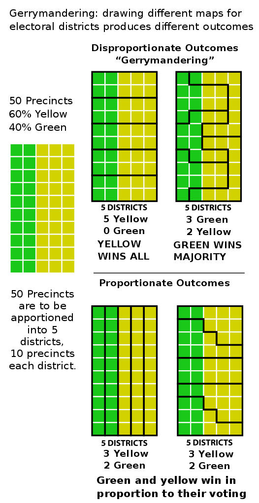
Gerrymandering is a method of shaping legislative districts in a way to give a particular political party an unfair advantage (or disadvantage). It is named for Elbridge Gerry, the governor of Massachusetts from 1810 to 1812 (and later the Vice President under President James Madison), who signed a bill in 1812 that used the technique to create such a district in Boston…a district that critics said was shaped like a salamander (hence, Gerry-mander).
Here is an illustration (taken from Wikipedia) of how shaping legislative districts can result in unfair and disproportionate outcomes:

Although I despise partisan gerrymandering, it is usually not illegal. The U.S. Constitution only states that “representatives…shall be apportioned among the several states…according to their respective Numbers,” which is set using the Census. The actual breakdown of each state into congressional districts is left to the state legislatures. And, of course, the states have almost complete authority over their own districts for their state legislatures.
There is some limited federal authority under natural law (i.e., relating to human rights), and the federal government has some specific election-related authorities under several constitutional amendments. But, generally, this isn’t federal business. If you don’t like gerrymandering, take it up with your state government.
I would be open to considering a constitutional amendment to set stricter guidelines for the establishment of congressional districts (although the federal government should not interfere with state legislature districts).
One approach might be to limit the number and types of borders — say, no more than eight borders, and each border must be an existing political boundary (e.g., a county line), a natural feature (e.g., a river or ridge), a major highway that has been there for at least ten years, or a straight north/south or east/west line. This would not eliminate gerrymandering, but would make it much harder to do effectively.
Another method might be to give the federal government the authority to establish a fair, transparent mechanism for determining boundaries. For example, an open source tool could be developed that uses census data and some other parameters to draw the districts. As long as this is open to inspection to ensure fairness, it would be the ideal approach. Interested parties could review the code and, if they find any hidden cheats, take it to the courts (or the press).
